NAVDATA AND MAPS FOR AUSTRALIA FROM OZRUNWAYS

OzRunways offer their Hybrid VFR map for Australia that combines all WAC, VNC, VTC and insets. They also offer a VFR NavData database for SkyView pilots.
Loading the NavData database into your SkyView system enables airspace, VFR waypoints and airports to be displayed on the Dynon basemap and allows direct-to, the creation of flight plans and use of nearest functionality directly on your panel mounted avionics. Also included are runway and VHF frequency details for each airport, as well as all ALAs from the OzRunways Airfield Guide!
OzRunways charts can be purchased on their
website.
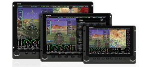
Using charts on your SkyView system
After you have installed maps to your USB memory sticks, simply connect them to your SkyView display(s) to enable charting capabilities. The USB memory stick(s) must be left connected to your SkyView display(s) during normal use for maps to be available.
Enroute-charts such as sectionals, ICAO charts, and IFR LO/HI (products vary by region) can be overlaid on SkyView by going to MAP > LAYERS, and then selecting the layer you would like to see.


 Proudly built in the U.S.A.